
History of the area
The history of the territory that today belongs to Castiadas is older than you might expect: a beautiful Nuragic complex, menhirs, domus de janas, and giants’ tombs confirm that the area has been inhabited since pre-Nuragic and Nuragic times. Furthermore, thanks to research carried out by the Superintendency of Cagliari, it has been possible to identify several Punic and Roman settlements in the areas of Cala Pira and Santa Giusta.
Belonging to the territory of “Sarrabus” (clearly derived from the ancient term Sarcapos), the municipal area had a strong commercial character in the past, frequently used by the Phoenicians on the route to Etruria.
The territory later became Roman, and in the Middle Ages, it took the name Villanova Castiadas and became an integral part of the Giudicato of Cagliari; with the Aragonese conquest, Castiadas was granted to the Quiterano (a Catalan family that became extinct in 1361) before passing under the control of the Carroz.
As late as 1316, some areas of what is now Castiadas were part of the Curatoria of “Tolostrai”, and can be located around San Pietro and near the Mountains of Villacastiadas.
It was in the final decades of the 14th century that the center of Villanova Castiadas was born in Sarrabus. Abandoned at the end of the 16th century due to frequent epidemics of malaria and plague, it remained desolate for about 350 years.
Castiadas made headlines again in the first half of the 19th century, when the authorities of the Sardinia Region began to complain about the presence of numerous Sardinian territories needing reclamation, as they were potentially usable as either pastures or agricultural fields. To minimize the clearly high reclamation costs, in 1871 the General Directorate of Prisons in Rome began proposing various possibilities. The most favored was the establishment of new agricultural penal colonies on the island, specifically aimed at reclaiming vast marshy and swampy areas through hydraulic works.
In January 1875, numerous officials assisted by technicians from the Civil Engineering Department of Cagliari visited various areas of Sardinia, and the choice fell on Salto di Castiadas, a totally degraded and completely depopulated territory. On June 2, 1875, the Chief Engineer of Civil Engineering, Bertolini Giovanni Carmelo, visited the territory, traveling on horseback over 30 km of difficult paths while waiting for his colleague, Tita Luciano, to join him a few months later: explorations began in the areas of Santa Giusta, Cala Sinzias, and Gutturu Frascu.
They were later joined by the expertise of topographer Barile Giorgio, who prepared the first detailed mapping of the area, totaling 6,523 hectares, to be allocated to the Colony.
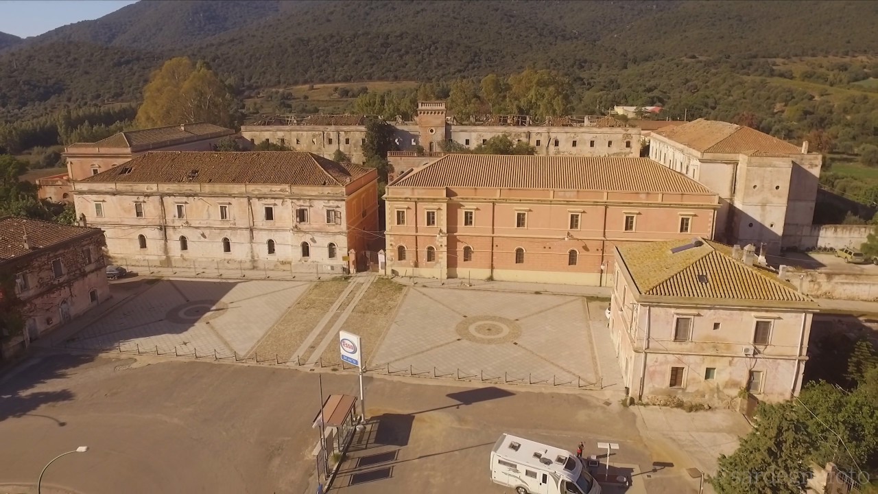
According to the documents submitted to the Ministry of Finance, the building was to be located in an elevated and possibly airy position, near springs and far from communication routes; therefore, the choice fell on the locality of Praidis.
In early June 1875, dozens of workers arrived, led by two master carpenters, to build the first huts: the operation immediately proved complex. The staff showed little enthusiasm, partly due to the location, partly due to low pay and the objective risk of contracting malaria; it also seems that the area was frequented by numerous smugglers.
In this regard, there was a timely denial: the prison administration had precise reports drawn up by the Carabinieri station in Muravera, which stated that the area was absolutely peaceful in terms of public order, due to the fact that extreme isolation reigned in Castiadas.
In a relatively short time, the largest agricultural penal colony in Italy was born, and with it, the territory of Castiadas saw a new light.